Matterport Accuracy for BIM: When ±20 mm Is Enough
TL;DR: 3 things to know
- 01
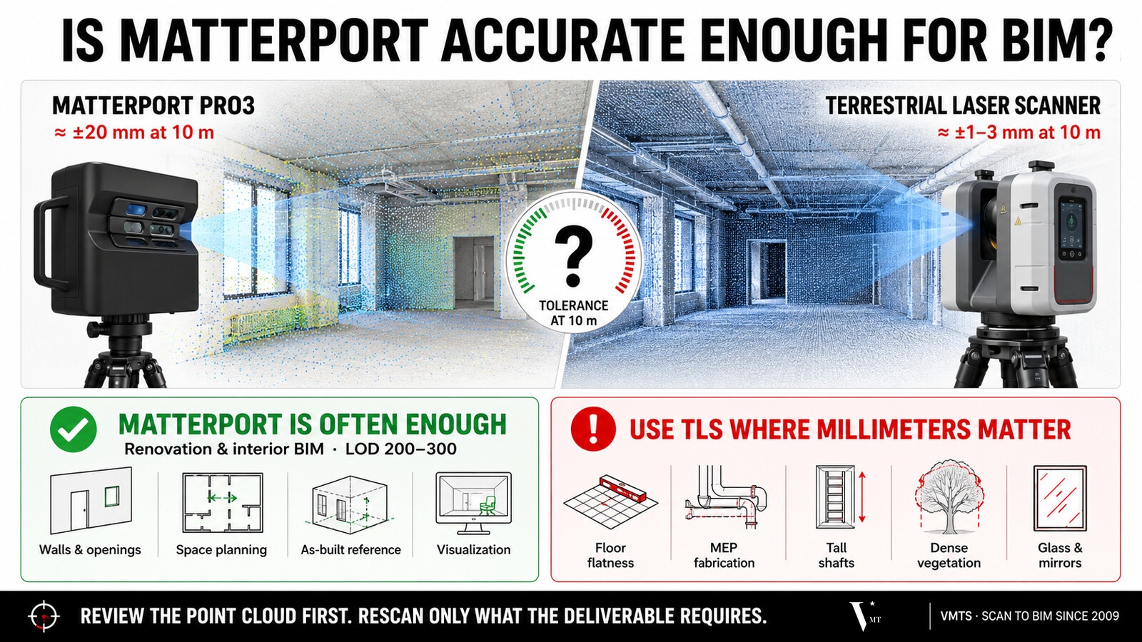
Matterport Pro3 accuracy is reported at roughly ±20 mm at 10 m, against roughly ±1 to 3 mm at 10 m for a dedicated terrestrial laser scanner. That gap is real, but it does not automatically rule Matterport data out of BIM.
- 02
For most renovation and interior BIM work at LOD 200 to 300, ±20 mm sits inside the tolerance already used in practice for wall and opening geometry. Matterport itself ships an LOD 200 BIM export directly from scan data, with no TLS step involved.
- 03
A rescan is still worth it for floor flatness certification, MEP fabrication, tall vertical shafts, dense exterior vegetation, and rooms with large glass or mirror surfaces. VMTS reviews the point cloud first and tells you honestly which category your project falls into.
It is a familiar sequence. A building gets scanned with a Matterport camera to produce a virtual tour, mainly for marketing or leasing purposes. Later, the same building needs a renovation, and the client sends over the Matterport online viewer link asking for a Scan to BIM quotation, usually adding that a terrestrial laser scanning (TLS) crew will be booked separately once the order is confirmed. Almost every time, that second scan is not necessary. This article explains what Matterport data can and cannot support in a BIM workflow, and where the line between the two actually sits.
What is Matterport data, and how accurate is it?
Matterport Pro3 combines a built-in LiDAR sensor with photogrammetry to generate a colored point cloud, a virtual tour, and, for scanning-only clients, an LOD 200 BIM export directly from the platform.
A Matterport scan captures the space with a camera that combines LiDAR distance measurement with photogrammetry, then stitches the individual capture points into one colored point cloud and a navigable virtual tour. The same underlying data can be exported as a point cloud file (E57) for use in CAD or BIM software, or, through Matterport’s own Scan to BIM product, delivered directly as an LOD 200 BIM file.
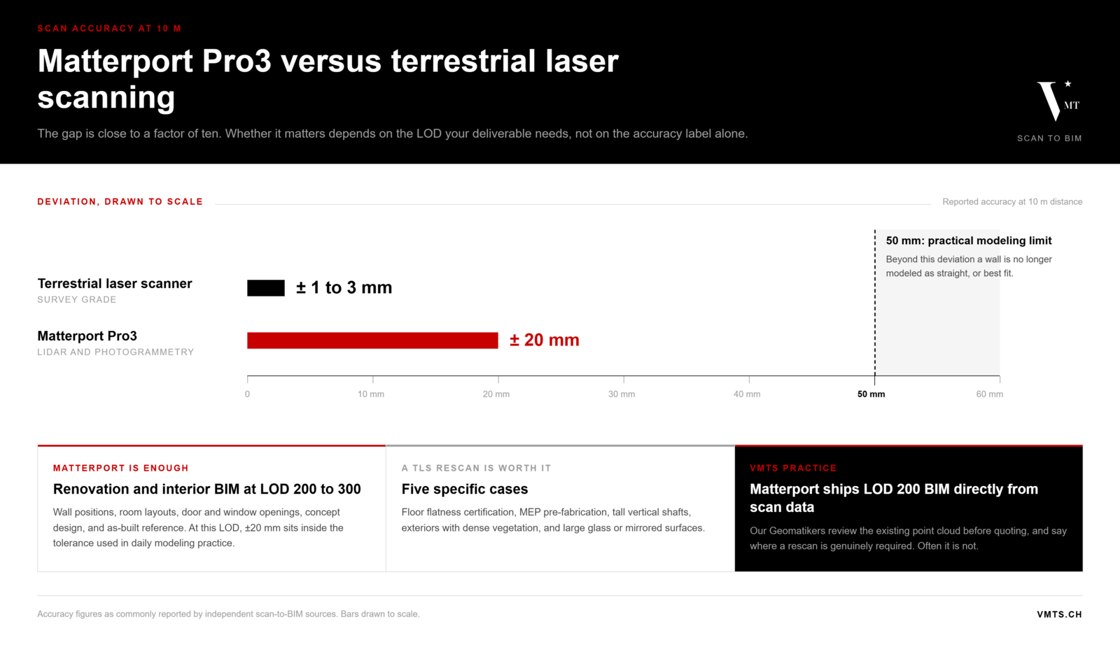
Independent scan-to-BIM specialists commonly report Matterport Pro3 accuracy at approximately ±20 mm at a 10 m distance. A dedicated terrestrial laser scanner, used for professional as-built surveys, is typically reported at roughly ±1 to 3 mm at the same distance. That is a real difference, close to a factor of ten, and it matters for some categories of work. It does not mean Matterport data is unusable for BIM. It means the two technologies are built for different jobs, and the right question is not “which is more accurate” but “how accurate does this specific deliverable need to be.”
Why clients assume a rescan is required
Matterport is best known as a marketing and leasing tool: virtual tours for real estate listings, hospitality, and facility walk-throughs. That association carries over into how the underlying data gets judged. If the scan was captured “just for the tour,” the assumption is that it cannot possibly hold up for anything technical, and terrestrial laser scanning gets treated as the only credible starting point for a BIM model.
General guidance from parts of the scan-to-BIM industry does not always help. Advice to “combine Matterport with laser scanning for the most reliable results” is technically true but rarely specific about when that combination is actually necessary and when it is not. Without that distinction, clients default to the safest-sounding option: book a full TLS rescan, even when the project scope never required survey-grade tolerance in the first place. The result is avoidable cost and schedule time, on top of data that was already sitting in a Matterport account.
When Matterport data is enough for BIM
Whether Matterport data is “enough” depends entirely on the LOD the project actually needs, not on a general accuracy label. For the majority of renovation and interior BIM projects, the target is LOD 200 to LOD 300: correctly located walls, doors, windows, and rooms, with real dimensions and correctly hosted BIM families, used for renovation design, permit planning, and space coordination. In that context, ±20 mm sits inside tolerances already used in daily modeling practice, where a wall is commonly modeled as straight, or “best fit,” unless the point cloud shows a deviation beyond roughly 50 mm.
Matterport data is generally sufficient for:
- Renovation and interior BIM at LOD 200 to 300: wall positions, room layouts, door and window openings, and overall building geometry for design and permit documentation
- Concept and early-phase design: feasibility studies, space planning, and preliminary layout options where exact millimeter tolerance is not the deciding factor
- Facility and as-built reference: documentation used for orientation, maintenance planning, or general space management, without a fabrication tolerance requirement
- Visualization and stakeholder coordination: combining the existing virtual tour with a BIM model for client review, without commissioning a second capture
VMTS Practice Note
Matterport itself ships BIM directly from scan data, at LOD 200, with no TLS step in between.
That is not a marketing claim from VMTS, it is Matterport’s own product positioning. It confirms that, at LOD 200, the manufacturer of the scanner considers its own data sufficient to build directly from, without an intermediate laser scan. The practical question for most renovation projects is whether LOD 200, or a carefully modeled LOD 300, meets the deliverable your project actually needs.
When a TLS rescan is genuinely worth it
None of this means Matterport data replaces terrestrial laser scanning across the board. A small number of deliverables have tolerance or capture requirements that Matterport, by design, cannot meet, and for these a TLS rescan is the right call, not an overcautious one.
| Situation | Why Matterport falls short |
|---|---|
| Floor flatness certification (e.g. ASTM E1155) | Matterport’s processing smooths the point cloud, which removes the fine surface deviation flatness checks depend on |
| MEP pre-fabrication and spool drawings | Pipe and duct centerlines need millimeter-level consistency; photogrammetry-based noise makes this unreliable |
| Tall vertical shafts and multi-story cores | Without gravity-referenced compensation, vertical drift accumulates over height |
| Exteriors with vegetation or dense planting | LiDAR from a dedicated TLS scanner penetrates sparse foliage to reach the ground; Matterport largely captures the leaf surface only |
| Large glass facades or mirrored surfaces | Reflective and transparent surfaces can create false geometry (“ghost rooms”) that distorts the resulting floor plan |
If your project includes any of these, plan for a TLS scan of that specific scope. It does not mean the rest of the building needs to be recaptured as well; the two data sources can be combined for the areas that actually require it.
VMTS Differentiator
We assess the data you already have, before recommending a rescan
This is the situation VMTS sees regularly: a client sends the Matterport online viewer link along with a request for a BIM quotation, and notes that a TLS rescan will be booked once the order is placed. In most of these cases, we tell the client directly that the rescan is not necessary, based on the LOD their project actually requires and what our Geomatikers can verify in the existing point cloud. Clients are consistently surprised by this, because every other quote they received simply assumed a full rescan by default.
How we decide, project by project
- Confirm the target LOD: we clarify what the deliverable actually needs to support, renovation design, permit drawings, or something with fabrication-level tolerance
- Review the existing point cloud: our Geomatikers assess coverage, density, and consistency of the Matterport data before quoting, the same independent verification step we apply to every point cloud, including TLS captures
- Flag any scope that genuinely needs TLS: if part of the project falls into one of the categories above, we say so specifically, rather than defaulting the entire building to a rescan
- Model and QC against the source data: the resulting BIM model is checked back against the point cloud, and any limitation of the source data is documented, not hidden
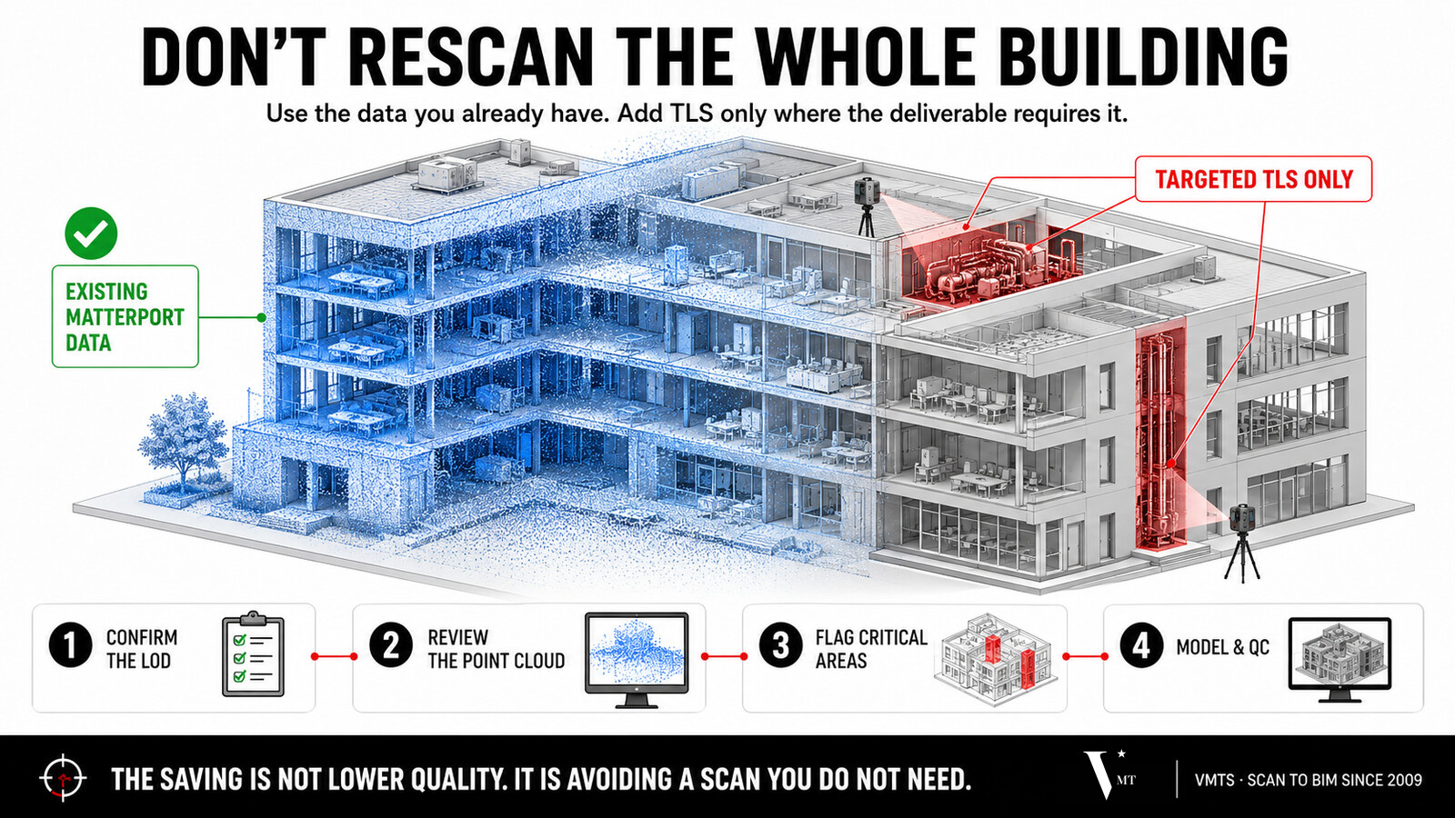
The benefit is not a lower price. It is not paying for a scan you do not need.
Skipping an unnecessary TLS rescan removes scheduling time for a second site visit and the cost of that capture, without lowering the standard applied to the resulting BIM model. Where a rescan is genuinely required, we say so before you place the order, not after.
This is a working example of our slogan in practice: “You scan, we support all downstream services, from point clouds to native BIM models.” Whichever capture technology produced your data, Matterport, TLS, or a mix of both, VMTS works with what you already have and processes it into a native BIM model, only asking for additional capture where the deliverable genuinely requires it.
VMTS as your Scan to BIM partner
VMT Solutions has modeled point cloud data into native BIM models since 2009, across Archicad, Revit, Allplan, and Vectorworks, for surveying offices, architecture firms, and engineering companies across the DACH region and beyond. Every project starts with an assessment of the source data by our Geomatikers, whether it comes from Matterport, a terrestrial laser scanner, or a combination of both, so the recommendation you receive is based on your project’s actual requirements, not a default assumption.
Read more about our broader Scan to BIM services, how our Geomatikers verify point cloud accuracy before modeling starts, or see the full list of deliverables you should expect from a Scan to BIM project.
Frequently Asked Questions
Is Matterport data accurate enough for BIM modeling?
For renovation and interior BIM projects targeting LOD 200 to 300, yes, in most cases. Matterport’s reported accuracy of roughly ±20 mm at 10 m sits within the tolerance typically used for wall and opening geometry at that LOD. It is not sufficient for floor flatness certification, MEP fabrication, or other work that requires millimeter-level tolerance.
How accurate is a Matterport scan compared to terrestrial laser scanning?
Independent scan-to-BIM sources commonly report Matterport Pro3 accuracy at approximately ±20 mm at 10 m, compared with roughly ±1 to 3 mm at 10 m for a dedicated terrestrial laser scanner. The gap is close to a factor of ten, but it only matters for deliverables that actually require that level of precision.
Do I need to rescan with a laser scanner if I already have a Matterport scan?
Not necessarily. It depends on the LOD your project needs and whether any part of the scope falls into a category that genuinely requires TLS, such as floor flatness certification, MEP fabrication, tall vertical shafts, dense exterior vegetation, or large glass and mirrored surfaces. VMTS reviews the existing point cloud before recommending a rescan.
What LOD can I get from Matterport data?
Matterport’s own Scan to BIM product delivers LOD 200 directly from scan data. With proper registration review and modeling by an experienced Scan to BIM team, many renovation and interior projects can reach LOD 300 from the same source data, depending on the condition and coverage of the original scan.
Does VMTS work directly with Matterport point cloud exports?
Yes. VMTS accepts Matterport point cloud exports (E57) as well as terrestrial laser scan data, and reviews the source data before quoting so that any recommendation for additional capture is based on the specific requirements of your project, not a default assumption.
Work with VMTS
Already have a Matterport scan? Send us the link.
Share your Matterport viewer link or point cloud export. We would be happy to review it and give you an honest assessment, including whether a rescan is actually worth it for your project.
Nguyen Huynh (Rainer)

About the Author:
Nguyen Huynh (Rainer) is Managing Director at VMT Solutions, specializing in Point Cloud to BIM workflows for surveying, planning, and engineering offices. He focuses on precise BIM models, clearly defined quality standards, and long-term technical partnerships.
Share This Story!
Related Posts


Recent Posts




We are proud to have
satisfied customers.

 Gerd Gindullis, Lecturer for digital as-built data capture at Aachen University of Applied Sciences, TerraMeta 3D Laser Service
 Stefan Schramm, Architekt Stefan Schramm
„Your plans are perfect; I’ve never seen anything like this before. These are drawings of the highest quality, I must say. I want to express my sincere thanks once again for your work.“
 Endre Szokolai, Digitalplan-Szokolai
VMT modeled a large industrial building in 3D for our research project. We provided DWG plans to VMT, and they delivered a highly detailed model, including the building envelope, interior walls, openings, and stairs. We had previously contracted a German company for the same object, but unfortunately, it didn’t work out. I was relieved and pleased that VMT handled it so reliably. Thank you for the excellent work and the truly fair price!

Very reliable company, courteous staff, and top-quality work. Our plans were created quickly and accurately. Thank you for that. Highly recommended.

Excellent advice and high 3D modeling quality at a great price-performance ratio… What more could you want? I can highly recommend them…